Cemeteries & Locations - A – F
ABANDONED CEMETERY
Located at the edge of a creek branch that runs into Bear Creek with tributaries running into Onion Creek, this burial ground is an abandoned cemetery with three or four graves which are still marked with some limestone rocks, but which do not have any inscriptions carved on them. It appeared that there may have been more graves at one time and upon investigating and researching, we discovered that the burial site had been visited in the recent year or two by people looking for their ancestors. However, after contacting these people in Dodge City,Kansas, it did not appear to be the cemetery they were trying to find, and it is not known who or what family is buried here.
The burial site is located on private property presently owned by Mr. L.W. Jones and his son of the Bear Creek Community. Mr. Jones can, and will willingly, show the site to those who have reason to visit it ~ however, after Mr. Jones is no longer around we are afraid that this particular burial site will become “ lost” to the ravages of time and mankind. It is located down the bluff behind a new home built by his son on the edge of what he called “No Name Creek” branch.
To reach Mr. Jones' home from the Friendship Baptist Church, located approximately five miles out of Driftwood on Hwy 1826, between Driftwood and Oak Hill, drive .6 mile north toward Oak Hill. On the right side of 1826 will be a gate with “L.W. Jones” on it. About .2 mile from this entrance gate is Mr. Jones' home. We are grateful to Mr. Jones for showing us the location of the burial site.
ABEL RANCH CEMETERY
Located on property owned by Herold “Buddy” Abel Jr., three miles out of San Marcos, in the community known as Stringtown, is a small burial site. It is thought to be the burial site for workers who lived on the property and worked for the property owners. It is not known who is buried in this plot of ground, nor the dates of any of the burials, as there are no stones with inscriptions. All that remains are rotted crosses and limestone rocks depicting the headstone and foot stones of graves. It is thought that this burial ground was for Hispanics. In our research we have often found records of a Hispanic burial simply to be “out on a farm” or “on the farm near San Marcos.” This could have been on any farm or ranch.
This little burial ground is a good example of how Cemeteries long ago abandoned become lost to the ravages of time. We are thankful to Buddy Abel for telling us of this cemetery and its location.
ADARE CEMETERY
(Also known as Wayside Cemetery)
30 Inscriptions
The Adare Cemetery is located 5.2 miles from the Wimberley Square via River Road, which veers right to Wayside Drive. Leaving the Wimberley Square follow R.R. 12 north to River Road. Continue to Wayside Drive; turn right up the hill. The gate to the Wenger Ranch will be reached at 4.3 miles; turn left through entrance and continue .9 mile to reach the cemetery. The cemetery is on land, which was once owned by the William Branch Adare family and set aside for the present cemetery. Located very near the Adare Cemetery is the lone grave of a small child (see Wenger Ranch Cemetery).
Permission to enter the ranch should be requested from its foreman, whose home is at the ranch entrance.
We are grateful to C.W. Wimberley for helping to record this cemetery.


ALEXANDER CEMETERY

2 Inscriptions
Located about four miles west of Dripping Springs on the Allene Breed Ranch on Barton Creek. Permission must be obtained before entering onto the ranch. If you are a descendant, you should have no trouble getting permission to visit this burial site.
An old iron fence within sight of the old Alexander home encloses the graves. P.D. Alexander, whose remains are buried in this family cemetery. He was elected County Judge in 1867 and served until 1878.Contray to local believes at that time, there is no evidence that P. D. Alexander fought for the Confederacy — no records have been found.
We are grateful to Mr. Cecil Griffin of Henly for proofing these burials, which were recorded approximately twenty years ago. The graves are still intact.
ALLEN CEMETERY

(Sometimes called the Allen/Good Cemetery)
28 Inscriptions
Located within the city limits of Buda, the cemetery is in very bad shape. The cemetery appears to be divided into three different sections. One section of the cemetery is surrounded by a 12” to 15'. thick rock wall approximately two and one-half feet tall, and approximately 40' x 50' in size. The graves inside this wall are in considerably good condition for their age. Nearby is the Severn family plot - measuring approximately 25 foot square - that is fenced with a wrought iron fence and a gate in very good working condition. The Stewart Iron Works of Cincinnati, Ohio manufactured the fence. These tombstones appear to be fairly new and in very good condition; however, scattered close by these two family plots are many graves in very bad condition.
Some are marked with stones that are broken, turned over and being trampled by livestock. This area encompasses approximately a half-acre of land. The stones in this un-fenced area will soon be lost to history unless family members take action to rectify the situation. * One piece of stone found lying on the ground had the initials B.F. inscribed on it.
The stone fence at this cemetery is worthy of a historical marker as is the cemetery. The earliest marked grave is that of P.J. Allen, who died in 1862. Possibly there were others earlier, but if so, they are not marked. According to lore, this cemetery was established when a flu epidemic passed through that section of the county.
* Since we first read this cemetery the Jardine Company purchased the property on which this cemetery lies. They have taken great pains to preserve the stones from further destruction. You can reach the cemetery by driving north on Loop 4 from downtown Buda past the railroad tracks to the entrance of the Jardine Company, located on left side of road. Drive into their entrance. The cemetery will be on the left of their road and is visible from that distance.


ANTIOCH CEMETERY
84 Inscriptions

Located near Onion Creek on what is known as “B.C. Road” is the Antioch Cemetery, which serves the Afro-American community of this area of Hays County. The “B.C.” stands for Black Colony, which is what the area was known as before the Civil Rights era of our history. The cemetery covers approximately one acre of land and it is kept mowed and clean. There are many old stones, with the oldest legible stone being that of John Bunton, sixteen-year-old son of E. and C. Bunton, in 1880. There is one other stone that possibly could have been in the 1870's, but is broken and the death year was not clear - Nellie Smith born August 10, 1861 and died December 20, 18 - (possibly 70 some odd).
The land for this cemetery was originally owned by Joseph Rowley, who sold it to Afro-American citizens for the purpose of colonizing, erecting a church and establishing a cemetery. We are indebted to Dorothy Schwartz who has researched the Black Colony area history of Hays County.
To locate the cemetery from downtown Buda, take FM Road 967 toward Camp Ben McCulloch and Dripping Springs. Go .4 mile, and turn to the left immediately after crossing Onion Creek onto County Rd 148. Follow this road for .1 mile to junction of Rd. 147 and go approximately one-half mile farther. The cemetery will be on your right just before the road makes a sharp turn to the right. It has a sign on the gate with the name of the cemetery on it; however, it is faded and you will have to look hard to see the sign. You will not miss the cemetery.


BADING CEMETERY
1 Inscription

The Bading Cemetery is located in what is known as the Centerpoint Community. The deceased members of the Gloetz, Mertz/Martz, and Badiong families, as well as other families, were interred in this cemetery. Most of the bodies were removed to other cemeteries years ago. Many were re-interred in the St. Geronimo Cemetery in Guadalupe County; however, there remains one stone. You have to look very carefully to find evidence that this is or was a cemetery. There is a rotting picket fence lying on the ground (1988 report; confirmed, 2007) which at one time surrounded one family’s burial plot. There is no fence surrounding the cemetery and livestock have been allowed to roam throughout the grounds. This burial site has been neglected and is in deplorable condition. If the area were raked and topsoil removed, there would probably be other tombstones, which have fallen or been pushed over and long ago covered with fallen leaves and dirt.
The cemetery was marked on the General Highway Map of the state (obtainable from the State Highway Department – TxDOT); however, it is marked on the wrong side of the road. This might be explained by the fact that the road was probably moved approximately 300 yards west of where it once ran years ago and the correction was not made of the exact location of the cemetery on the new maps.
To reach the cemetery from San Marcos, take I-35 south from its intersection with Highway 123. Go approximately five miles and take Exit 199 (Posey Road). Cross over I-35 and go east for 1.3 miles, to the junction with Co. Road 266 (Old Bastrop Road).Turn right and go .8 miles to junction with Co. Road 265 (Frances Harris Road), Turn left and follow the road for 2.8 miles, making a 90-degree right turn one half mile before reaching the site. The cemetery is on the left side of the road, about 100 feet inside the tree line. It is not easily recognizable. Visitors are advised to contact HCHC and seek landowner permission before entering. The stone marks the grave of a three-year old girl and the inscription is written in German. There is a poem on the bottom of the stone, also in German.
2007 Update: HCHC visited this site in 2007 and began a small-scale restoration project (see restoration page). As reported by earlier researchers Kerbow and Hearn, very little remains of the cemetery.
BARTON CEMETERY
310 Inscriptions

On November 25, 1881, James U. Barton, a citizen of Hays County who lived near the falls of Onion Creek, deeded to Arthur Barton, Henry Breedlove, Thomas Everet, John Y. Stephenson, and D.A. Porter “about three and one-fourth acres of land in consideration of one dollar” along with “the good feelings from my neighbors in the vicinity of Mountain City. “ The purpose being to “establish a burial ground for such white people only as they shall permit. “ Mr. Henry E. and E.B. Barber witnessed the deed.
There were at least fourteen burials in this burial site before the cemetery was established in 1881. The oldest marked grave is that of Thomas D. Robertson, who died in 1873. There are several Civil War veterans buried in the cemetery. Those persons whose graves are not marked, but whom it is known served in the Confederate States Army are: Odom N. Casselberry (1829-1894), Henry E. Barber (1841-1897), J.P. Carlton (1845-1912), J.H. Ferguson (1846- 1916), Jason L. Andrews (1841-1929). These names were taken from Tula Townsend Wyatt's Veterans Records in the San Marcos Public Library. There may be others.
The tombstone of Annie L. Blum (1879-1891), wife of W.M. Blum, shows she died at age 11 years and 11 months. This is in error. Researching the census records show that the dates are incorrect. W.M. Blum, if buried in the cemetery, has no stone.
2013 Update: Barton Cemetery remains a beautifully-maintained private cemetery. Paula Michaud of Buda is president of the Barton Cemetery Association and is the person to contact if interested in the site. The cemetery is located just off the west side of FM 1626, about a half mile north of FM 2770.
BLACKWELL CEMETERY
The Blackwell Cemetery is an abandoned cemetery adjoining the Wilson Cemetery. It is reported by some to be the same cemetery as the Wilson; yet others refer to the Blackwell Cemetery to be separate from the Wilson Cemetery. From Tula Townsend Wyatt's Veterans Records file found in the San Marcos Public Library, we found that she had listed two veterans buried in the Blackwell Cemetery - George Blackwell, died 1865, and Joseph Blackwell, died 1890. Both were veterans of the Civil War. George and Joseph were brothers. There is a story regarding the murder of George Blackwell on page 21 of Wimberley's Legacy as told by Joe Cruze. There are no stones remaining in this particular portion of the cemetery. There is one stone in the Wilson Cemetery.
These two family Cemeteries are located on Britt Burns' property. To reach the site, turn left at the Wimberley Bank in downtown Wimberley onto River Road at junction of River Road and RR 12. Follow road for .7 mile. Turn right and go .1 mile farther to a Y in the road. The cemetery is in the yard of a large home with a peaked roof straight ahead of you at this point. You must seek permission before searching the area.
BLANCO RIVER CROSSING CEMETERY
2 Inscriptions
This cemetery was established by Mr. Ezekiel Nance, ancestor of the present owner, David Allen. There were only two stones in this cemetery, recent ones of Dr. Kirkland and Beverly Jean Allen. It is reputed by some of the descendants of Mr. Ezekiel Nance that some of the Mexican ranch hands are buried at one end of the cemetery. There is evidence of several graves throughout the cemetery, which is approximately 25' x 75' in size. It contains two beautiful old wrought iron fences that surround the burial site of two unidentified persons. The cemetery is fenced with a modern chain link fence. It is on private property and permission must be obtained before entering the cemetery.
The cemetery is located just off County Rd 225, out of Kyle very near the low water bridge that crosses the Blanco River. As you cross the river from the Kyle side the cemetery is located approximately .2 mile up the hill on the left.
Dr. Roy Kirkland restored the cemetery. His widow, Elithe Hamilton Kirkland, told us there is an old shepherd from Mexico buried in the cemetery. Within the confines of the cemetery is a beautiful granite tabloid marker designed by Mrs. Kirkland and dedicated to the memory of her husband, its inscription reads:
What is this thing called death?
Only the shadow of the white dove's wing. What is the force that spirals us afar? The Spirit Life Unending. Child of God.
What is this current that sustains us here? Love from the Eternal Spirit, Love for all.
Excerpts from The Sacred Catechism
*Mrs. Elithe Hamilton Kirkland passed away at her home in Wimberley, Texas on January 4, 1992, and is buried beside her husband in this cemetery. Her grave is probably marked with a marker, making three marked graves in this cemetery. Mrs. Kirkland was a well-known author and inductee of The Texas Women's Hall of Fame. Author of several books and other writings, she was best known for her historical novel of early Texas, “Love Is A Wild Assault.”
BUTLER CEMETERY
45 Inscriptions

The Butler Cemetery is a private family cemetery located on property now controlled by Dr. Frank Zimmerman Jr. and his brother, Roger, attorney at law.
The property on which this cemetery is located was originally owned by Thomas Albert Smith (b. April 5, 1868/d. 1941), son of William Pitt Smith at the time land was set aside for a cemetery. The land had been obtained by J.C. Johnson in 1855 from Charles Travis, son of William B. Travis of Alamo fame, and later sold to the Smith family. According to a Smith descendant, Thomas Albert Smith is buried in the cemetery in an unmarked grave (Hays Co. Historical and Genealogical Society's Quarterly, Vol. III, # 3, p. 33). Thomas A. Smith sold the property to Beverly H. Butler. This land joined that of Thomas' father, William Pitt Smith. The cemetery encompasses approximately two acres of land. It is well fenced and when we visited it had been recently mowed. There are approximately 10 -15 unmarked graves that are visible to the eye.
By comparing a survey made in 1967, to the one we made, we found one stone listed on the 1967 survey no longer there. Either the remains were removed or vandals have carried off the stone. It is that of Benjamin G. Monsola, died Aug. 6, 1930 Sgt. Co. C. 143 Inf. WW 1. It is possible that the person making the survey in 1967 knew of Mr. Monsola's burial and listed him even though he may not have had a stone; however, as the military record was also listed, it probably was marked.
There is a large crypt made of concrete and large rocks which stands approximately two feet tall, three to four feet wide, and eight feet long marking a grave which has no identification on it. Who is buried there was unknown when our first printing was published. We have since learned from Mrs. Tell E. Hat lock, Jr. of Austin that this crypt contains the remains of a John C. Hayes.
William Austin Hayes, whose remains are in this cemetery, served in the Civil War. He was in Co. C, Texas Cav., Duff's Regt. His stone does not give this information.
In researching historical documents relating to this cemetery, we found additional information on three of the deceased persons buried in Butler Cemetery. Because the cemetery is not easily accessible and because this information is regarding persons born in the 19th century, we are including it in this short history. 1. Hrs. Georgia Butler was born Hay 8, 1865, and died Feb. 15, 1928, at age 64 yr., 9 mo., and 7 days. She was the daughter of Thomas Whisenant. 2. Hiss Lizzie Butler was born on February 12, (year not given stone gives 1842) and died June 6, 1930, at age 88 years. She was the daughter of Reese and Lucy Heeks Butler. 3. Beverly H. Butler was born July 5, 1887, and died April 21, 1938, at age 50. He was the son of John B. and Lucy Heeks Butler. Further historical facts may be obtained by contacting the descendants who are members of the cemetery association. The Butler Cemetery Association is very active. They meet twice a year to clean and maintain the cemetery. Visitors wishing to visit the cemetery should contact Hr. Blue Johnson of San Marcos for further information. In addition to the above information found in research during 1989 we received correspondence in 1994 from Marjorie R. Hobley of Austin, Texas. She furnished additional dates and family genealogical data about some of the persons buried in this cemetery, including maiden names as well as a list of persons she believes to be buried there who do not have markers. This information will be available for research in our Hays County Archives when it becomes open to the public.
To reach the Butler Cemetery located on the Zimmerman Ranch from downtown Kyle go west on Center Street from railroad tracks for .5 mile to intersection of County Road # 150. Turn right onto 150 and travel for 8.3 miles to intersection of 150 and F.H. Rd. 3237. Stay to the right on 150 (at Hays City). Go 2.4 more miles to entrance of Zimmerman Ranch on right side of road. There are two gates into the ranch. One has the name over it. Gates are locked and permission to enter must be obtained. From the gate(s), drive .9 mile into ranch on paved, winding road. There will be an opening in fence (gap or gate).
Turn right into pasture and immediately back to right beside fence line. Drive .1 mile down fence line; turn left and drive another.1 mile, veering to the left. This is a pasture full of cedar trees and stumps and it is advisable to be in a pickup truck or four-wheel drive vehicle. The cemetery is in a clump of trees (invisible from the road).
We are thankful to Mr. Buck Payne of San Marcos for arranging for our entrance and to U.L. and Cassia Hodge for accompanying us on this project.


ByrdOwen-Payne Cemetery
8 inscriptions


The Byrd Owen-Payne Cemetery is located in an area of Hays County south of downtown San Marcos known as Stringtown. It is at the southern tip of Stringtown. This area was settled in the early 1840s and was “strung out” along the road; thus the name “Stringtown.” Mr. Byrd Owen was on of the earlier settlers of this area; however, he is not buried in this little cemetery. His remains lie in the San Marcos City Cemetery. The earliest grave is that of Ellie H. Owen in 1879, a two-year old daughter of W.H. and Lizzie Owen.
The cemetery is almost destroyed (1988) from cattle and other livestock having been allowed to roam over it, At one time there was a fence surrounding the site. Mrs. Kutscher, who lived (1988) on the farm adjoining the property where the cemetery is located, and whose ancestors (Poseys) once owned the land, told us that when they had the property, her husband leapt the fence up and took care of it. She also said that her husband had a gate on the road and a lane open to the cemetery. It has in the last few years been fenced so that you cannot enter without crossing private property. We found only eight stones, but there is evidence that many more burials were made there.
Mr. Doyle Williamson of the Hugo area of Hays County (1988) remembered attending the funeral of his grandfather Payne in 1912, when he was a young lad. The family “camped out” overnight.
In research we found records showing that a male Netherland family member had been buried in this cemetery, He died July 24, 1910; was born in Kentucky, and was the son of Benjamin Netherland.
To reach the cemetery from downtown San Marcos, go west on West Hopkins until that street becomes Hunter Road. There is a traffic light at the intersection of Hunter and Wonder World Drive. Continue on Hunter past this intersection for 3.6 miles, a short distance past Centerpoint Road. The cemetery is on the right side of the road, 25-30 yards from the roadside.
Thanks (1988) to Lydell Clayton, whose husband’s ancestors are buried in this cemetery, for accompanying us to this location and helping copy the inscriptions. Thanks, also to Mr. Eugene Herry, Jr., the present landowner, for allowing us to enter. Mr. Herry was surprised to learn that the bodies had not been removed from this cemetery.
1994 update: Under supervision by the Hays County Historical Commission’s Winton Porterfield and their leader, a San Marcos Boy Scout troop cleared the site. A fence was erected around the cemetery and a sign (Byrd Owens-Payne Cemetery) erected.
2008 update: Restoration of the site was once again undertaken by the Hays County Historical Commission, cemetery chairman Jim Cullen re-visiting the site in May 2008 for a complete grounds clean-up.
Byrd Owen-Payne Cemetery Restoration Project
CAMINO REAL CROSSING CEMETERY
SEE CEMENTERIO DEL RIO
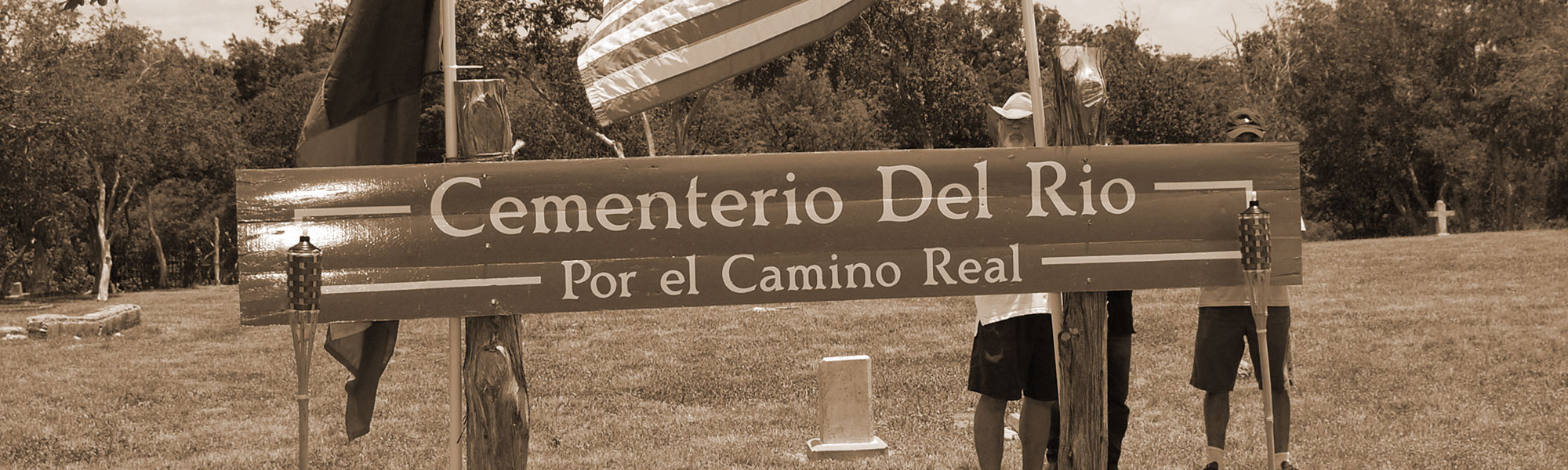
CEMENTERIO DEL RIO (also known as Camino Real Crossing Cemetery and Westerfeld Crossing Cemetery)
46 Inscriptions (read in 1990s)


This site is currently (2007) referred to as Cementerio del Rio, though landowners in the area have previously referred to it as Camino Real Crossing Cemetery (so-designated in the 1990s-era Hays County Cemeteries Inscriptions publication of HCHC members JoAnn Hearn and Dorothy Kerbow) and Westerfeld Crossing Cemetery. It is located on land adjoining the Baugh Ranch (Rancho del Camino Real) and the Hilliard Farm (1990s owner), on the San Marcos River, just below the Westerfeld Crossing). It long served the Hispanic community of San Marcos.
Current access to the cemetery is by an approximately two-mile long ranch road north from Staples Road (FM 621 from San Marcos to Staples in Guadalupe County), and condition of the mostly dirt road is contingent on rainfall (and would not be recommended after heavy rains).
The cemetery covers approximately three acres of land and is in relatively poor, unrestored condition, though Hays County some years ago did set up an agreement with San Marcos contractor Gene Bagwell to periodically mow and trim the site. Cattle having access to the site is an ongoing problem and does not bode well for maintenance of even the status quo at the site. Adjoining the San Marcos River, it is believed recurring floodwaters eroded the river bank, possibly taking tombstones. The Hearn-Kerbow publication stated “At one time this cemetery must have been one of the prettiest in Hays County,” and the assessment of the picturesque site remains accurate more than a decade later. Their 1990s-era report of “many wooden crosses, which are rotting” no longer holds true, those remains apparently relegated to a “dust to dust” fate. Many indications point to numerous unmarked grave sites.
Researchers Hearn and Kerbow’s 1994 revision of their cemetery inscription book credited cemetery activist Winton Porterfield and the local LULAC organization with working at that time to clean and restore the cemetery. Today, San Marcos historian Ofelia Vasquez-Philo maintains the most active interest in and conservation of the site.
To reach the cemetery from IH 35 in San Marcos, go east on Highway 123 (toward Seguin) to the FIRST light. Turn left at the light and take this road (FM 621, or Staples Road) for approximately 2 miles to an intersection with Old Bastrop Road (a commemorative stone monument noting an old route of El Camino Real can be seen about 50 yards to the left from this intersection). Continue past the intersection about a quarter mile – to the FIRST ranch gate on LEFT. Enter the gate and follow the ranch road its full length of about two miles. The road dead-ends at the cemetery.
2013 Update: Cementerio del Rio was designated a “Historic Texas Cemetery” by the Texas Historical Commission, ca. 2011, and The Hays County Historical Commission hosted a THC Historical Marker dedication at the site on June 16, 2013 (see Hays Free Press report, San Marcos burial site earns its place in history, by Jordan Gass-Poore’, July 10, 2013). A number of changes/improvements have taken place at the site since the last (2007) description, starting with the complete perimeter fencing of the cemetery which removed the long-time, ongoing damage done by cattle on the ranch where the cemetery is located.
The cemetery’s four largest tombstones, all Woodmen of the World stones and previously all toppled--were professionally righted and leveled by Wimberley stone restoration specialist Don Hudson, thanks to assistance from the office of Hays County Commissioner Debbie Ingalsbe. Many dead and dying trees—victims of the ongoing drought of the past several years—were removed through the courtesy and efforts of the Hays County Road Department, again with funding assistance through Commissioner Ingalsbe’s office. The HCHC Cemeteries Committee has overseen much recent individual tombstone leveling by assistant Richard Gomez. And regular yard maintenance continues as a part of the county contract that maintains a total of seven county cemeteries and historic sites.
Access to the site through the private property is still through the gate described in the history (above), though a combination lock now prevents unlimited access. That access can be arranged by contacting either Ofelia Vasquez-Philo or Jim Cullen of San Marcos.
CEMENTERIO GUADALUPE
185 Inscriptions

Guadalupe Cemetery or Cemetery de Guadalupe as it is named in Spanish is a Hispanic cemetery located a short distance out of San Marcos on the old Austin Highway (Post Road). It is located 1.2 miles past the entrance to Aquarena Springs on the left side of the road. The cemetery is fenced with a chain link fence and it is kept clean and mowed on a regular basis. There are many graves in the cemetery which are not marked. Many are marked with only funeral home markers which are temporary as they are easily destroyed, unintentionally, while mowing or raking grass. There is a gate to enter into the cemetery which is kept locked; however, there is a small gate through which you can walk which is open at all times.
As this cemetery serves the Hispanic population of this area of the county, most stones are written in Spanish. We tried to record as much information from the stones as space would allow.
A survey was made of the cemetery in 1975, by Tula Wyatt and Mary Compton, in which they marked the exact location of each burial recorded. This survey is in the San Marcos Public Library in the Tula Townsend Wyatt collection. Many of these grave sites are no longer marked.
We are thankful to Cassia Hodge for accompanying us to this cemetery and helping copy inscriptions.
CHEATHAM- HOHENBERG CEMETERY
10 Inscriptions


The Cheatham-Hohenberg Cemetery is a private family cemetery located atop one of the tallest knolls in the San Marcos area. It is a beautiful as well as a peaceful site. Cheatham Cemetery is the final resting place of the first Hays County Judge, Henry Cheatham, his wife, a son and daughter-in-law, and eight grandchildren (8).
Historical Background
Judge Henry Cheatham’s father, William Cheatham, was born in 1762 in Chesterfield County Virginia. When he was sixteen years of age, he enlisted in the Virginia Militia and off and on over the next four years he took part in various battles and patrols in the Revolutionary War. Henry Cheatham was born in 1798. His baptismal cup, a silver goblet bearing the initial “H.C.” and the date “1798” is in the possession of a great-great-grandson. (3)
The family moved to Cumberland County, Kentucky, in 1807 and it was there that young Henry grew up. On December 26, 1826, Henry married Martha Branch Walthall. In 1827 the young couple moved to Nashville, Tennessee, where they remained for several years and then in 1833, they moved to Washington, Arkansas. Henry Cheatham’s two children were born in Washington, Arkansas. His daughter, Sarah Branch, on September 28, 1837, and his son, Henry Clay, on January 6, 1843. In 1846/1847 the Cheatham’s continued the western migration by moving to Texas, to the part of Travis County which was soon to be split off to form Hays County. They settled on a plantation just south of the Blanco River below San Marcos. (3) The original Cheatham property is part of the Thomas G. McGehee league of 1835.
The Cheatham’s, in their rambling two-story southern home on the Blanco River, made their contribution to the early development of San Marcos. But the spacious old house served as more than a happy home. People from the surrounding territory gathered in it when Judge Henry Clay Cheatham, first judge of the new-born Hays County, held court there. Travelers in quest of a place to lodge did not make their way to a hotel or tavern; instead, they went to the Judge Cheatham’s place with its sincere, old-fashioned hospitality, was inviting to everyone.(1)
On March 8, 1848, Will Pitts would be commissioned notary public to conduct the first elections of the newly organized Hays County. Fifty county residents took part in the election when Henry Cheatham was named Chief Justice (4). After serving two years as judge, Cheatham was elected commissioner and served at intervals for a number of years. Cheatham was paid $3 a day for service on the Commissioners Court (7). In 1855, he was appointed overseer of the road to Gonzales by Chief Justice J.C. Watkins. (5)
Judge and Mrs. Cheatham were also among the founders of the Presbyterian Church in San Marcos in 1853. (4)
“During the campaign of 1857, Houston came to San Marcos to speak….it was learned that Houston would spend the night in the home of Judge Henry C. Cheatham which was situated on the Blanco River below town. A Committee selected twelve young ladies and twelve young men, all dressed in white and riding white horses, to escort General Houston from the Cheatham home to San Marcos”. (2)
Judge Cheatham’s wife, Martha, dies in 1872. Judge Cheatham died in 1885 at the age of 87 and was buried in their private graveyard on a small hilltop, around the foot of which slave cabins clustered in the old days. With him died the Cheatham name except for the slaves, who on being freed after the Civil War, in many cases used the names of their former masters. (3, 9)
In 1897 Ernst Hohenberg purchased the Cheatham house. (10) Ernst Hohenberg was the second owner of the Cheatham property. He had left Germany at sixteen to avoid serving in the Prussian army. With a companion, Ernest Allman, he walked over much of Texas looking for work. Employment at York Creek led to acquaintance with and marriage to Antonie Bading, daughter of Fritz Bading, an attorney in New Braunfels. By the time they came to the farm on the San Marcos River their first son, sixteen-year-old Martin, died, and was buried “on the hill,” the beginning of a new family burial place alongside the Cheatham family cemetery. The Hohenbergs added acreage to their original purchase until this farm comprised about 400 acres. It was the Hohenberg family home for 50 years. (4) Ernst Hohenberg was given 5 years for the murder of Thomas Bell, who was killed in an altercation in the streets of San Marcos in April 1900. (11) According to the Denton City News, he was later acquitted. (12)
To reach the cemetery from the intersection of I 35 and U.S. Hwy 80, in San Marcos, drive east toward Luling on Hwy 80 for 2.2. miles to the junction of Caldwell County Rd 101. Turn right onto 101 and drive .1 mile to a road crossing 101 (Old Martindale Road). Turn right. This will be Hays County Rd 295. Drive west toward San Marcos for .8 mile. The cemetery will be on the right side of the road atop a knoll. It cannot be seen from the road. You will need to get permission to climb the hill as it is on private property. When we visited the site, there were several fences we had to climb as well as pass through cattle feed lots.
Inscriptions |
Born |
Died |
Henry Cheatham |
9/21/1798 |
7/13/1885 |
Martha Cheatham (wife of Henry) |
10/24/1807 |
6/12/1872 |
Henry Clay Cheatham (son of Henry/Martha) |
1/6/1843 |
1/26/1871 |
Sally Lena Cheatham (wife of Henry Clay) |
4/12/1840 |
9/26/1874 |
Antonia Hohenberg |
4/13/1858 |
12/13/1943 |
Ernst Hohenberg |
1/2/1858 |
11/30/1940 |
Martin Hohenberg |
12/15/1881 |
3/9/1898 |
Fritz Hohenberg |
9/22/1896 |
6/3/1910 |
Roland Hohenberg |
4/21/1899 |
7/18/1918 |
Gertrude Beidler |
6/18/1894 |
10/11/1980 |
1) The Cheatham Burial Plot, by Hattie Mittendorf, The San Marcos Record-25 September 1936
2) Early History of Hays County by Dobie, Page 25
3) Hays County Historical and Genealogical Society (excerpts from) Vol. IX, 1975
4) Clear Springs and Limestone Ledges, A History of San Marcos and Hays County by Frances Stovall, Dorothy Wimberley Kerbow, Maxine Storm, Louise Simon, Dorothy Woods Schwartz, Gene Johnson
5) Commissioners Court Minutes, Book A, page 3, Hays County Clerk 1855 overseer to road
6) Commissioners Court Minutes, Book A, Hays County Clerk
7) Commissioners Court Minutes, Book A, page 35, Hays County Clerk 1857 $3 per day pay
8) The only known source of information about the Cheatham babies who died is the Cheatham Family Bible.
9) According to the 1850 Census Slave Schedule, Henry Cheatham owned 21 slaves.
10) HCDR Vol 33, page 308
11) The Houston Post (Houston, Texas) Mon, Sep 30, 1901, First Edition Page 3
12) Denton County News (Denton, Tex.), Vol. 12, No 11, Ed. 1 Thursday, June 25, 1903


CHERRY SPRINGS CEMETERY
(Also known as the Crapps Cemetery)
4 Inscriptions


Cherry Springs Cemetery was established in 1873, when three acres of land were set aside by J.W. Lee. He gave seven acres for the Church of Blanco Circuit West Texas Conference of the Methodist Episcopal Church.
There are approximately twenty unmarked graves at this location. Jeremiah Lee is buried in this cemetery, but his stone is no longer there. He fought in the Civil War. Only four graves are legible. There is one stone that is partially legible with the name and year of birth missing. It reads: b. Nov. 12, -, d. Nov. 24, 1892. Perhaps this is the stone of Jeremiah Lee. Daughters of the Confederacy records would possibly show the date of his birth and death.
As we went to print with the first printing of this book, we were contacted by a gentleman by the name of Bobby Bryant of Deer Park, Texas, whose ancestors are buried in the Cherry Springs and Gatlin cemeteries. He sent us a copy of a sworn statement made by Dora Ardella Bryant Pickel, born 1896, and daughter of Alexander Bryant, stating that her father is buried in the Cherry Springs Cemetery on the Lynn Storm (ed. note – Scott Storm Ranch, 2009). She also swore that her father knew his paternal grandparents to be Hiram Bryant, born 1802 in Tennessee and died in 1884. She stated that both are buried in the Cherry Springs Cemetery in Hays County. A copy of this affidavit will be placed in our cemetery files. This statement also gives names of persons buried in the Gatlin-Garrett cemetery. Mr. Bobby Bryant plans to erect stones at their grave sites; therefore, anyone visiting the cemetery in a few years will probably find more listings than we have included.
In Dorothy Wimberley Kerbow’s recently (1994) published book, “Wimberley, Texas, Historic Belle of the Blanco,” there is a history of the Crapps family as told to her by a descendant of the Crapps family, Billy Leath Pellerin of Wimberley.
Located on the Storm Ranch between Dripping Springs and Wimberley on RR 12, permission must be obtained to enter the cemetery. The Storm family (today—2009—represented by Scott Storm) has always been very cordial and have shown the cemetery to all family descendants and others who are interested in the area. Scott or someone he designates will have to accompany visitors to the cemetery as the ranch is quite large and visitors likely will not be able to find it on their own. The Hays County Historical Commission remains appreciative to Scott, as it was for many years toward his parents, the late Maxine and Lynn Storm.
2009 Update—Cherry Springs Cemetery remains on Storm Ranch property and, as with Gatlin-Garrett Cemetery, is in need of a historic survey, preceded by a partial clearing which would fully expose all of the site’s fading features. As with other Hill Country cemetery sites, Cherry Springs (or Crapps) Cemetery features a number of stone enclosures of presumed grave sites within which there are no longer any markers. The tombstone of Lemuel Crapps (1808-1892) survives. Notably, three modern stones have been placed (see 1994-era plans—above—of family to do so) immediately adjacent to the original, deteriorating tombstones of Hiram Bryant (1802-1881, Texas Scout Company, 9h Texas Cavalry,Co. E), his wife Mary (1807-1884) (Hiram and Mary both born in Wilson County, Tennessee), and their grandson, Alexander Bryant (1860-1916).
CHRISTAL CEMETERY
5 Inscriptions
In researching records in the Tula Townsend Wyatt Collection in the San Marcos Public Library, we found in the Veterans file a notation regarding two Civil War veterans being buried in the Christal Cemetery. It took several weeks of inquiry before we found what used to be the Christal property. We then proceeded to visit the area and found the cemetery. It is located on private property and permission must be obtained to enter; however, the landowner takes pride in the cemetery and often puts flowers on the graves. Descendants of the Christal family have in recent years erected a new fence and tombstones for those whom they knew to be buried there. The landowner will gladly show you the cemetery if you are a descendant of the family.
Buried in the cemetery are the remains of five Christal family members. There was also an unmarked grave which since 2002 bears a CSA veteran’s marker for Peter Wüthrich(1829-1923). This appears to be a mistake. Peter Wüthrich’s death certificate and obituary indicate he is buried in Austin’s Oak Hill Cemetery. He is also commemorated with a stone in the Wüthrich Family Cemetery on his former ranch over two miles away.
Buried beside Roland Christal, who is also a CSA veteran, is his first wife. We were told that he married a second time and that his second wife is buried in the Dallas, Texas area.
We owe special thanks to Daryl Howard who took the time from her art studio to show us the cemetery and to point out the exact location of a nearby lone grave of Isham J. Good.
To reach the Christal Cemetery, located in the Bear Creek area of Hays County, take FM Road 1826, east just out of Driftwood at the intersection of Co. Rd 150 and Rd 1826. Drive toward Austin for 5.8 miles to the intersection of Co. Rd 163. Turn left onto 163, and travel approximately one mile. On the left of the road will be a home and an art studio. The address was Route 27, Box 252, Austin, Texas in 1990. The gate will be closed and locked in most instances; therefore, it would be advisable to contact Ms. Howard before driving out to visit.
COCKE CEMETERY
5 Inscriptions


What is known today in Hays County as Cocke Cemetery takes its name from the imposing granite stone bearing the family name inside the one-acre sight. This central stone is surrounded by five smaller headstones, their inscriptions bearing the given names or initials of Cocke family members and their dates of birth and death. The family plot, roughly 15’ X 15’, is enclosed by an ornate cast-iron fence. Additionally, the entire one-acre cemetery is surrounded by the same style cast-iron fencing. Only three more tombstones—directly in front of the small Cocke family enclosure at a distance of about fifteen feet—are to be found in the entire cemetery. These three tombstones are all from the Labenski family, related to the Cockes by marriage.
The extended property on which the cemetery is located was first occupied by William Henry Harrison Carpenter, who in 1854 purchased a 400-acre tract of land from Augustine B. Slaughter out of the P.J. Allen league (1) book 3 page 362. Carpenter, who had taught school in the Shelbyville, Kentucky, area as a young man, married Jane Todd of that town on March 10, 1836. Jane’s father and Mary Todd Lincoln’s father were first cousins and the Carpenter family tradition holds that a close family relationship existed between the families. Tradition further holds that W.H.H. Carpenter and his wife were among the wedding guests when Abraham Lincoln and Mary Todd were married. The future president, according to Carpenter family lore, used the W.H.H. and Jane Carpenter home as a stopping place on the way to Virginia court.
When purchasing the Hays County land in 1854, W.H.H. Carpenter selected the highest of three hills on the property on which to build his home. A Texas Historical Commission historical marker is mounted on one of the still-standing Carpenter log cabins on what is still referred to as “Carpenter Hill,” within a few hundred yards of Cocke Cemetery.
Carpenter, who had earlier worked as a teacher in Kentucky and Illinois initially occupied himself as a teacher at the first school in today’s Buda area, the Kellyville School. The experience was relatively brief and he soon turned exclusively to managing his northern Hays County farm.
Though not immediately evident, the above background on W.H.H. Carpenter does help fill out the larger story on Cocke Cemetery, as on May 15, 1870 (2), one of Carpenter’s daughters, Mary Eliza Kate Carpenter, married Fred Cocke, establishing the relationship between the two families. In Oct 1868 Fred Cocke purchased a parcel of land described as League no. 1 on the waters of Onion Creek for $100(3) from his future father-in-law, giving him a presence on the earlier 400-acre property.
It is unclear whether today’s surviving cemetery is on the land Cocke bought or whether it sits on property retained by Carpenter. The dramatic physical evidence of the large Cocke family stone (easily one of the largest in Hays County) suggests the former, but other evidence suggests the possibility that the cemetery may have been on property retained by W.H.H. Carpenter.
The better-documented Carpenter local history firmly establishes Cocke Cemetery as the burial site of both W.H.H. Carpenter and his wife Jane, who died June 9, 1890 and January 10, 1897, respectively. The earliest (1975) documented read of the cemetery noted no surviving Carpenter tombstone, confirmed by the last few years of Hays County Historical Commission clearing of the badly-overgrown site. At least one other Carpenter family death, that of W.H.H. son, William Shawnee Carpenter (May 8, 1876), happened on the family farm during the years of the cemetery’s active use. It is clearly an assumption with no physical evidence today, but no tombstone for William Shawnee Carpenter survives anywhere in the area and, as the Carpenter (and extended Carpenter) family was utilizing their family cemetery—and the death was the result of an accident (fall from a horse) at the family farm, it is not a very great stretch of logic to assume this Carpenter was buried at the site, as well.
Completing the early Carpenter-Cocke relationships with the other three surviving stones in today’s cemetery are the three Labenski stones located just outside of the inner Cocke enclosure. The families’ relationship was established when W.H.H. Carpenter’s daughter Frances Jane married C. C. Labenski in October, 1869. The surviving Labenski stones document Charles C. (1844-1918), his wife Fannie C. (1844-1883), and Minnie H. Labenski (1855-1896). Further census research should determine Minnie’s relationship to Charles C. Labenski. Within approximately a mile of the previously-mentioned THC-marker Carpenter Log Cabin is the Labenski log cabin, badly deteriorated and marginally surviving near Buda and Onion Creek. According to Clear Springs & Limestone Ledges (1) book 3, page 360, Charles C. Labenski served with Gen. Hood’s Texas Brigade and was wounded at Franklin, Tenn. During this battle 6,500 Confederate soldiers were killed and 12 Generals died, one of which was Gen. Pat Cleburne.
The Cocke family’s origins are well-established, with distinguished roots back to Tennessee, though the arrival in Texas and subsequent movements of the family’s head, Frederick Bird Smith Cocke, are less clear. According to the website, “The Political Graveyard,” F.B.S. Cocke (reported here as 1813-1903) was “born in Rutledge, Grainger County, Tennessee February 13, 1813. Grandson of William Cocke, son of John Alexander Cocke; grandfather of William Alexander Cocke. Member of Texas state house of representatives, 1861-63, 1879; delegate to Texas state constitutional convention, 1875. Died in Center Point, Kerr County, Texas, April 28, 1903. Interment at Cocke Family Cemetery.” It should be noted for specificity that his headstone in Cocke Cemetery notes a February 6, 1812, birth. The death dates from the two sources agree. It was this senior F.B.S. Cocke’s son, also Frederick B. S. Cocke, who married into Hays County’s Carpenter family in 1870.
Besides that of the senior F.B.S. Cocke, individual headstones in the relatively small Cocke plot include his son Fred (1839-1912), daughter-in-law Kate (Carpenter) (1850-1913), granddaughter Minnie (April 3 – June 19, 1875), and grandson William Melton (1876-1897).
As mentioned earlier, the first read of the cemetery took place in 1975 and was performed by R.C. Barton and his wife, Mary, for the Hays County Historical and Genealogical Society. In approximately 1994, Hays County Historical Commission members Jo Ann Elam Hearn and Dorothy Wimberley Kerbow, accompanied by then-Hays County Constable Billy Reeves, visited the site while researching county cemetery sites for their book on the county’s tombstone inscriptions. They described the site as being “in very bad condition. It is overgrown with vines, brush, and briars. We had to hack our way through the thorny brush to reach the stones.” The overgrowth prevented the researchers from finding the Labenski stones, located within only a few feet of the interior Cocke enclosure, and reported by the Bartons two decades earlier.
The Texas Historical Commission’s Anne Shelton and Hays County Historical Commission’s Jim Cullen visited the site in 2006, finding it exactly as Hearn and Kerbow had described it years earlier. In 2007, Buda Scout Brad Webber undertook the clearing of the cemetery as his Eagle Scout project and, enlisting the pivotal help of the Hays County Road Department and other Scouts, largely cleared the site and created a chipped wood walkway from the gate to the inner Cocke family plot. The Hays County Historical Commission maintained the site until 2010, when Hays County Commissioners included it in a re-worked private maintenance contract that covers several abandoned county cemeteries.
Bibliography:
- Clear Springs and Limestone Ledges. A history of San Marcos and Hays County by Frances Stovall, Dorothy Wimberley Kerbow, Maxine Storm, Louise Simon, Dorothy Woods Schwartz, Gene Johnson.
- Hays County Marriage Records
- Hays County Deeds Record Book. Doc 189, Book OPR, Vol. J, Page 208.


CORONADO CEMETERY
(also known as La Luz Cemetery)
11 Inscriptions (recorded in initial reading; additional inscriptions located, 2007)


The cemetery takes its posted name from Francisco Coronado (1863-1908) according to Coronado family history, as a burial ground for Hispanic residents of the old Goforth Community area in northeastern Hays County. Coronado was killed in 1908 and his fenced burial site contains the cemetery’s oldest surviving tombstone.
The cemetery was identified as “La Luz Cemetery” in the 1990s publication by Hays County Historical Commission members JoAnn Hearn and Dorothy Wimberley Kerbow. That name was taken from then-area residents who associated its location with an old road named “La Luz Road,” so called because of a one-time bright light that shined in the area, lighting that particular road at night. Hearn and Kerbow concluded the light was “probably a rotating searchlight or landing light from a nearby airport used by the military.” They also refer to historical documents using the names “La Luz,” “Laluz,” and “Luce,” though noting “probably the cemetery never had an official name.”
Subsequent to the 1990s Hays County cemeteries publication, Austin descendants of Francisco Coronado, citing family heritage of events leading to his death and the cemetery’s founding, erected permanent signage titling the site “Francisco Coronado Cemetery.” Absent the earlier documentation on “La Luz” as a site name, it seems appropriate that current usage designates the site by Coronado’s name.
The cemetery’s present-day condition can best be described as “poor, but improving” with volunteer help. It is currently unfenced.
Approximately fifteen tombstones remain in 2007, a few more than located in the 1990s when the site’s pervasive cane growth prevented a thorough inspection. The Coronado family reports there were once many more grave sites marked with wooden crosses, now gone. The site was the scene of a 1991 cleaning by the Knights of Columbus, Council 9038 in Buda, more recent 2006-2007 work by Lehman High School Honor Society students (and other present-day volunteers) the only organized effort since. The Lehman NHS recently received Texas Historical Commission approval of their “RIP Guardian Program” application (*See “Restorations”).
To reach the cemetery from IH 35 near Buda (approximately 17 miles north of San Marcos), take the Niederwald Exit and turn east (right) on 2001. Go approximately .1 mile and turn right, staying on 2001. Drive 5.1 miles farther to the intersection of Co. Road 157 and 2001. Turn right on 157 and go .9 miles to intersection with Mathias Road. Turn left on Mathias and go 1.7 miles (to Coronado Lane). The cemetery is located on the right side of the road.
Coronado Cemetery restoration project


CRUZE CEMETERY
18 Inscriptions
The Cruze Cemetery is a private cemetery. It is located on the Whisenant Ranch out of Wimberley. The land once belonged to Santa Anna Cruze, an early pioneer in the Wimberley area. There is quite a bit of history relating to Santa Anna Cruze, and if you are interested in the Cruze family, you will find his history in the libraries in both San Marcos and Wimberley.
This cemetery holds the remains of Chief Gray Eagle, who died in 1857. The cemetery is located 6.1 miles from the Wimberley Square on PM Rd 3237 (Kyle Road). Permission must be obtained from the Whisenants before entering the cemetery. There is at least one unmarked grave. Perhaps this is the grave of Santa Anna Cruze or Joe Cruze.
2008 Update: HCHC Cemetery Committee members Dorothy Gumbert, Bob Flocke, Linda Coker, and Jim and Luanne Cullen, with the permission of Norman Whisenant of San Marcos, visited the site Memorial Day weekend. The current landowner is Dalton Pape, but Mr. Pape—who opened the gate on FM 3237 immediately in front of the site--directs all inquiries about the cemetery to Whisenant descendants in the area.


DRIFTWOOD CEMETERY
500+ Inscriptions


Driftwood is a small community located in the north central part of Hays County at the junction of Farm or Ranch Road 150 and County Road 170. There is a Baptist Church, Community Meeting House, a Post Office, and a store, which is not presently open. The cemetery is located next to the Methodist Church, and according to Mrs. Minnie Lea Rogers in her history of Driftwood, it was established in 1884.
The cemetery is well taken care of. It is fenced with a chain link fence. There were nearly three hundred marked graves, with either a headstone or a funeral home marker when we read the cemetery.
Driftwood was called Liberty Hill until 1886, when the citizens applied for a post office. It was discovered that there was already a Liberty Hill post office established and it was not too far removed from the Driftwood area.
It was discussed and decided that the citizens would rename their community Driftwood. You may possibly find a reference to a burial at Liberty Hill, which may in fact be a burial in Driftwood. Even though the name of the community changed, it was several years before people stopped referring to it as Liberty Hill. Since we read this cemetery a Texas State Historical Marker has been erected inside the cemetery.
The names and lives of the cemetery's inhabitants can be found in these heavily researched and categorized personal biographies by our Cemetery Committee. Please notify us if there are any errors or omissions in the descriptions for us to maintain accuracy. Email: Sally Ramirez


DYE CEMETERY
2 Inscriptions
Located on a hilltop, on property surrounded by land owned by Tom Harper, lies a very small family burial ground. There are two marked graves in the 20' x 20' fenced area. There is indication of three more graves, being marked with large limestone rocks. They appear to be graves of adults.
Mr. Sam Brooks, whose family last owned the land before it was sold and subdivided, was the last person to be interred in the cemetery. This was in 1988. His grave is marked only with a funeral home marker because, we were told, the landowner refuses to let the monument company drive to the location with a truck to erect the stone which the family wishes to place at his grave. We were told also that a lawsuit has been filed by the landowner to force the family of the deceased to remove the bodies and do away with the cemetery .We do not know if this is true; however, there is a law protecting Cemeteries and burial grounds from desecration. No one can willingly do damage to a burial site.
To reach the cemetery from the Henly Fire Department on U.S. 290, go west toward Johnson City for .3 mile to the junction of County Rd 165. Turn left onto 165, and drive .4 mile to the junction of County Rd 190. Turn left onto 190, and drive 1.7 miles to a point in the road where it forks. Stay to the right leaving 190, and enter onto a gravel county road (198). Drive 1.1 miles and turn right onto a caliche/gravel drive into a subdivision. Go .1 mile. On the left will be a “small” mountain or “large” hill. Atop this knoll is the cemetery.
FITZHUGH CEMETERY
600+ Inscriptions

The Fitzhugh Cemetery was created when the Batts family donated two and one-half acres of land for both a church and cemetery. This makes up for the original portion of the cemetery. Sometime in the 1960's or 1970's, Mr. Fred Shields, whose property adjoins the cemetery, donated an additional one acre to be used for burial purposes.
The earliest date we found on a marker was 1875; however, there may have been earlier burials. There were not many graves in the 1800's. Eleven graves were moved to the cemetery from Hudson Bend Cemetery in 1931, when Mansfield Dam was built on the Colorado River, and five graves have recently been moved there from the old Marx Family Cemetery in Travis County, Texas.
The cemetery is located behind the Fitzhugh Baptist Church in the little community of Fitzhugh. Fitzhugh is in the northwestern part of Hays County very near the Travis County line, on Hays County Rd 101, where it intersects with H.C. Rd 185. This is approximately seven miles north of Dripping Springs. It is right next to the road and cannot be missed.


FULTON CEMETERY
Fulton Cemetery, located just out of Wimberley near Jacob's Well, can no longer be found. Present day residents, including the old-timers of Wimberley, do not know of its existence; however, the burial of two Civil War veterans in this cemetery are recorded in the Tula Townsend Wyatt Collection at the San Marcos Public Library. They are: Antonio Duran and J.B. Fulton. It is recorded that their graves bear no inscriptions. The cemetery was recorded as being close to Jacob's Well, as were two other Cemeteries, which we discovered were actually closer to Dripping Springs than to Jacob's well.
Thanks to the Pedernales Electric Cooperative who allowed us to look through their maps of that area and whose employees offered to keep a lookout for this lost cemetery.
In early 1994 we found a cemetery located on the Campbell Ranch off Hays County Rd 219, which has two headstones with no inscriptions. We believe this to be the Fulton Cemetery but have not yet proven it to be.